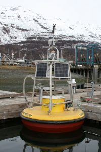
In February, the Council reached an agreement with Alyeska that will improve knowledge about weather conditions in Port Valdez. Alyeska has agreed to allow a buoy to be installed in front of the Valdez Marine Terminal to measure winds and surface currents. A second buoy will collect data from a nearby salt marsh.
Agreement reached on appeal to amendment of spill contingency plan
The agreement is the outcome of an appeal to a 2017 amendment to the oil spill contingency plan for the terminal.
In that 2017 amendment, Alyeska replaced a tool used by responders in deciding whether to protect the salt marsh known as the Valdez Duck Flats, and the Solomon Gulch Fish Hatchery in case of a spill from the terminal. The Council, the City of Valdez, the Valdez Fisheries Development Association, and the Prince William Sound Aquaculture Corporation appealed the 2017 change. They were concerned the new tool would not adequately protect these two environmentally sensitive areas.
Eastern Lion spill in 1994 taught lesson in protecting sensitive areas
In 1994, the tanker Eastern Lion spilled crude oil into Prince William Sound while loading at the terminal. Oil from that spill reached the marsh and hatchery. It was determined that the contingency plan lacked a rapid decision-making tool for oil spill responders to use early in a response.
After that spill, federal and state agencies, the industry, and the Council participated in a facilitated, collaborative process to develop a tool that would protect the hatchery and salt marsh. The result, a decision matrix, was implemented in 1997 to ensure that protective boom is deployed before oil could reach these sensitive areas.
New workgroup to find a resolution
In exchange for dismissing the appeal, all parties will participate in a facilitated collaborative workgroup to reach consensus on how to ensure protection of the Duck Flats and hatchery. The 1997 matrix will remain in place until the workgroup concludes.
“The Council has long advocated that robust weather monitoring systems be placed at the Valdez Marine Terminal,” said Donna Schantz, executive director for the Council. “We are required by the Oil Pollution Act of 1990 to study wind and water currents and other environmental factors in the vicinity of the terminal facilities, to determine how they might affect the ability to prevent, respond to, contain, and clean up an oil spill. These weather buoys will help us better achieve that goal.”
Donation and grant will help support data collection
To support these efforts, the Council has received a donation of two weather buoys from Fairweather Scientific, a subsidiary of Edison Chouest Offshore.
The first buoy, placed near the terminal, will be supported by the Council. A grant from the City of Valdez will support operating and maintenance costs of a second buoy, placed near the Duck Flats. It is anticipated that both buoys will be in operation for at least the next five years.
The wind and waves on the southern side of Port Valdez can be remarkably different than those recorded at the official weather stations located onshore in Valdez.
“Weather is a significant factor in the management of safe crude oil transportation through Prince William Sound,” added Schantz. “Marine safety, tanker escort operations, oil spill response planning, containment boom tactics, and oil tanker movements are all affected by weather. We are pleased by the support received to help us collect important scientific data to help prevent oil spills and improve response efforts should prevention measures fail.”
The buoys are expected to be in place this spring. Data from the buoys will be available online once they are in place and operating.
Photo: The Valdez Duck Flats is designated as a “environmentally sensitive area” in spill contingency planning.