By Jeremy Robida
Council Project Manager
This year, the Council completed a multi-year study with the Prince William Sound Science Center to better understand how water circulates within Port Valdez. The study documented seasonal changes to the circulation due to fresh water runoff in spring and summer as well as seasonal wind patterns.
The data from this project will help improve oil spill prevention and response planning. Knowing how sea currents and wind affects oil movement on water, as well as the effects on consistency and amount of water mixing into the oil, in turn affects how an oil spill is contained and cleaned up.
New technology
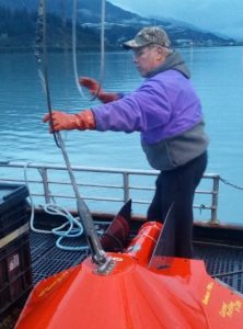
A major effort to understand Port Valdez circulation was done in the early 1970s when the Valdez Marine Terminal was constructed. This recent project used better technology and instrumentation now available to build upon that previous work. In the earlier study, researchers had to use binoculars to find the drift buoys with small attached flags. The new drifter buoys were all GPS enabled. These buoys not only measured surface flow and wind patterns, but some of the buoys captured data over 100 feet below the surface.
Other new technology, such as the Acoustic Doppler Current Profiler, which was towed alongside a vessel, provided a significant amount of data on underwater flow patterns as well. This technology simply didn’t exist when the original baseline environmental work was first conducted and this helped fill in some of the gaps left in the work from the 1970s.
Results
The project revealed that there are circulation patterns present in Port Valdez that vary by season. Winds, if blowing, tend to overtake and dominate these circulation patterns.
Effects of the fresh water layer
During summer and fall, when fresh water runoff is at its maximum and air temperatures are highest, water in the port is highly stratified and layered, causing the large scale rotations present to be more pronounced. These large scale circular patterns are overtaken and dominated by winds, however, particularly in the summer. The surface waters generally move in the direction of the current, unless overtaken by wind.
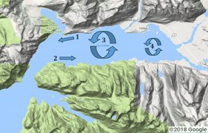
Summer sea breezes tend to blow towards the town of Valdez from the Narrows. In the winter the winds reverse, blowing towards the Narrows. Given the high degree of stratification in the summer, wind can only penetrate down to approximately 30 feet, whereas in the winter, when temperature and salinity is more uniform through the water column, wind can affect circulation several hundred feet below the surface.
In addition to circulation and water movement, the study also:
- Provided temperature and water salinity at various depths in various seasons. This will be useful for making decisions about the use of dispersants in Port Valdez.
- Looked at the amount of time water spends in Port Valdez. This information could help determine whether dispersed oil would be flushed from the port or sink to the bottom, where it would concentrate.
- Mapped out areas that would likely be impacted by an oil spill, according to season.
Read the full report:
Circulation in Port Valdez, Alaska
Article correction 8/21/2018:
- A previous version of this article stated: “These buoys not only measured surface flow and wind patterns, but some of the buoys captured data up to 100 feet below the surface.”