Collaboration promotes navigation safety and protection of coastal marine resources
The Council has partnered with the National Oceanic and Atmospheric Administration to establish PORTS® information for Valdez, Alaska. PORTS® (Physical Oceanographic Real-Time System) improves the safety and efficiency of maritime commerce and coastal resource management by providing real-time environmental observations, forecasts and other geospatial information to mariners. To help bring this resource to Valdez, the Council is streaming data from two new weather buoys to PORTS®.
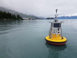
In 2019, the Council worked with regional partners to deploy two buoys in Port Valdez; one off Jackson Point at the Alyeska Pipeline Service Company’s Valdez Marine Terminal and one near the Valdez Duck Flats. These buoys collect data to improve understanding of the meteorological and physical oceanographic environment at the terminal and Duck Flats.
The objectives of the PORTS® program are to promote navigation safety, improve the efficiency of U.S. ports and harbors and ensure the protection of coastal marine resources. The Council is mandated by Congress to study wind and water currents and other environmental factors in the vicinity of the Alyeska terminal which may affect the ability to prevent, respond to, contain and clean up an oil spill. The Council works with industry and regulators to ensure response readiness, evaluate risks and propose solutions. Allowing these weather buoys to integrate with PORTS® furthers these efforts while also meeting the system’s objectives.
“While the Council’s sole purpose for installing these buoys is to promote the environmentally safe operation of the Valdez Marine Terminal and associated tankers, we believe the integration of this metocean data into NOAA’s PORTS® will benefit and improve safety for a variety of other maritime users,” said Donna Schantz, executive director for the Council. “This is another excellent example of how collaborative science can have wide-ranging impacts for the betterment of all.”
Data from the buoys is already being provided to the Alaska Ocean Observing System. AOOS is a network that consolidates critical ocean and coastal weather observations and related information products. By monitoring the state’s coastlines and ocean waters, AOOS helps provide the information needed by residents to make better decisions concerning their use of the marine environment.
“This new system, and the others like them around the country, reduce ship accidents by more than 50 percent, increase the size of ships that can get in and out of seaports, and reduce traffic delays,” said Steven Thur, Ph.D., acting deputy director of NOAA’s National Ocean Service. “They also provide real-time, resilience-ready data as coastal conditions rapidly change, potentially threatening our coastal communities.”
- Valdez PORTS (Access via Mobile or Text)
- AOOS:
- Data from the Valdez Marine Terminal buoy
- Data from the Valdez Duck Flats buoy
The buoys were made possible through donations from Fairweather Science and partnerships with the Prince William Sound Science Center, Alyeska Pipeline Service Company, the City of Valdez and Valdez Fisheries Development Association. The installation has been permitted by several agencies and cooperation with the U.S. Coast Guard and Alyeska Pipeline Service Company has allowed the Council access into the marine security zone that borders the terminal.
The Council has a direct interest in the successful operation and maintenance of weather buoys and stations installed in Prince William Sound because weather affects safe oil transportation and spill response.