New buoys will collect data about winds and currents in Port Valdez

Photo of VMT Buoy in Valdez harbor
Update June 2019: This new buoy, pictured here in Valdez Harbor before being moved to its monitoring location near the terminal. The buoy is now streaming data, which can be accessed through our weather tracking page

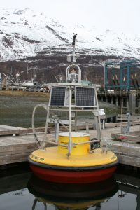
In February, the Council reached an agreement with Alyeska that will improve knowledge about weather conditions in Port Valdez. Alyeska has agreed to allow a buoy to be installed in front of the Valdez Marine Terminal to measure winds and surface currents. A second buoy will collect data from a nearby salt marsh.

Agreement reached on appeal to amendment of spill contingency plan

The agreement is the outcome of an appeal to a 2017 amendment to the oil spill contingency plan for the terminal.

In that 2017 amendment, Alyeska replaced a tool used by responders in deciding whether to protect the salt marsh known as the Valdez Duck Flats, and the Solomon Gulch Fish Hatchery in case of a spill from the terminal. The Council, the City of Valdez, the Valdez Fisheries Development Association, and the Prince William Sound Aquaculture Corporation appealed the 2017 change. They were concerned the new tool would not adequately protect these two environmentally sensitive areas.

Read more

New study analyzes weather at Hinchinbrook Entrance

A recent Council-sponsored report found that wind and waves at Hinchinbrook Entrance may be under reported as observed by the Seal Rocks weather buoy.

Researchers from Tetra Tech analyzed wind and wave data to better define weather conditions at the Entrance, as well as how these conditions might affect rescue operations by the escort tugs. To do this, researchers looked at the frequency and duration of weather events when the Entrance was closed to laden tankers.

Average closure conditions

A "wind rose" graphic that shows the speed and direction of wind as recorded at Seal Rocks.
This “wind rose” graphic shows the speed and direction of wind as recorded at Seal Rocks.

Wave height alone was found to be the cause of most of the closures, occurring 10 to 26 times a year on average. Average wave height during closures was over 17 feet and the highest recorded wave was over 26 feet. Wind speed closes the Entrance one to three times annually, as do closures for both wind and waves. Winds average just over 54 miles per hour during closure and the highest recorded wind speed was over 61 miles per hour.

Closures for winds typically last less than two hours, while waves close the Entrance for an average of just over six hours.

Seal Rocks buoy’s data may not be precise

Read more

Out-of-service buoy and winter storms raise concerns

An out-of-service buoy and a series of recent storms have combined to raise concern at the Council about tanker transit procedures during period with the high wind speeds and wave heights in which tankers are allowed to travel through Prince William Sound.

Seal Rocks buoy out of service


From May until December of 2018, a critical buoy located near Hinchinbrook Entrance was out-of-service. This buoy, referred to as “Seal Rocks buoy,” collects wind speed and wave height data. That information is used by the U.S. Coast Guard to make decisions as to whether Hinchinbrook Entrance is open or closed to outbound laden oil tanker traffic. When this buoy is inoperable, the U.S. Coast Guard uses data from two nearby buoys, Cape Cleare and Cape Suckling, along with reports from Edison Chouest Offshore, or ECO, tug crews that are sent out to observe wind and waves to make Hinchinbrook Entrance open and closure decisions.

In November and December, several winter storms came through Prince William Sound that raised concern about these alternate methods for reporting weather conditions at the Entrance.

Read more

30 years after Exxon Valdez


NEW: 35 years after Exxon Valdez


How has oil transportation changed in Prince William Sound since 1989?

Image of cover of Then and Now 30 Years After the Exxon Valdez Oil Spill
Read more about the changes and remaining concerns in our new publication: Then and Now: 30 Years After the Exxon Valdez Oil Spill (PDF)

The immediate cause of 1989 Exxon Valdez oil spill was a navigational error on the part of the tanker’s captain and crew. However, Congress found that complacency among the oil industry and the regulatory agencies responsible for monitoring the operation of the Valdez terminal and vessel traffic in Prince William Sound was also a contributing factor in the disaster.

Few prevention measures were in place and cleanup resources were inadequate.

Since 1989, regulatory agencies, the industry, and citizens have been working together on improved methods to prevent oil spills and how to be better prepared to clean up if another spill should occur.

Laws and Regulations

One of the most important results of the oil spill was the enactment of the federal Oil Pollution Act of 1990, or “OPA 90,” which addressed many deficiencies, including liability, compensation, and oversight. The law required two citizens’ oversight councils, one for Prince William Sound and one for Cook Inlet.

Both federal and state laws now require more comprehensive prevention measures and planning for larger spills and require more spill response equipment to be immediately available.

Read more

Skip to content